
StrataSite™ Critical Incident Mapping

Critical Incident Maps by StrataSite™ meet and exceed state grant funding requirements for schools across the United States developing incident response plans.

SCROLL TO SEE CRITICAL INCIDENT MAPPING

CRITICAL. COMPREHENSIVE. COMPLIANT.

Critical Incident Mapping

StrataSite™ Critical Incident Maps meet the following requirements included in key grant funding programs:

  • Printable format
  • No additional software required
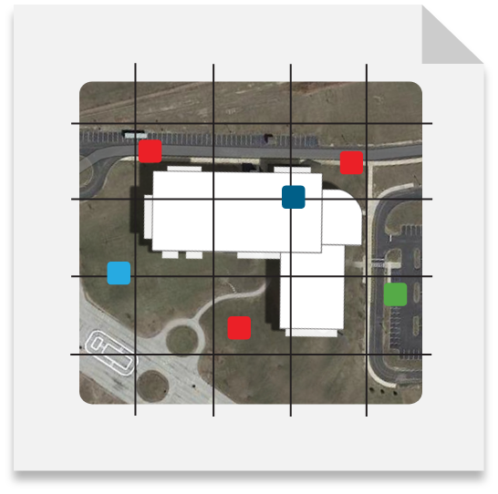
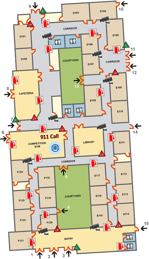
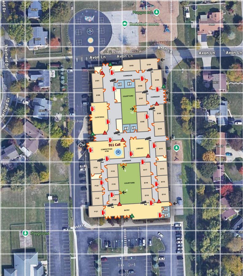
  • Building floor plans overlaid on aerial imagery
  • Gridded (x/y) coordinate system with an alphanumeric projection for quick site references
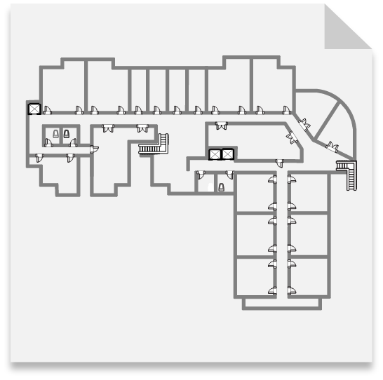
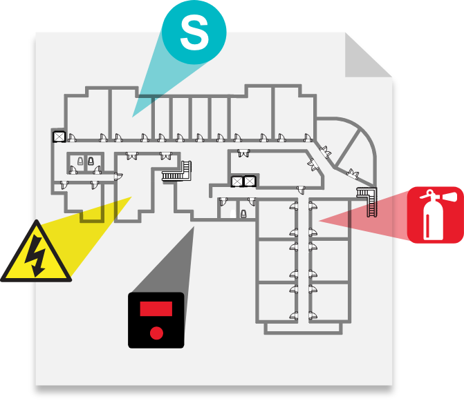
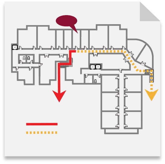
  • Building-specific labeling for rooms, hallways, doors, stairwells, locations of hazards, utility locations, key boxes, defibrillators, and trauma kits
  • Site-specific labeling that matches the school grounds, including parking areas, athletic fields, surrounding roads, and neighboring properties

BUILD YOUR CRITICAL INCIDENT MAP WITH STRATASITE IN 4 EASY STEPS.

Your Floor Plans
1

Your Floor Plans
StrataSite will create your floor plans, or we can use assets you already have. Our team will ensure you have an accurate building layout to use in Site and Floor Plan views.

Identify Critical Plan Components
2

Identify Critical Plan Components 
StrataSite will work with you to clearly designate and indicate the location of all critical plan components.

Review and Finalize
3

Review and Finalize
StrataSite will take you through the review process to achieve your printable maps. Our unique consulting approach will leave you with an unparalleled ability to create a coordinated multi-agency response.

Response Plans & Training
4

Plan Delivery
StrataSite will provide you with your required maps and related worksheet-response plans — printed, or as a digital file.

Critical Incident Map Features

Print-Ready Plan
Print-Ready Plan

Maps are formatted for print or digital access

Aerial Images
Aerial Images

Building floor plans overlaid with current aerial imagery

Grid Coordinates
Grid Coordinates

Gridded overlay with x/y coordinates oriented to true north

Site-Specific Labels

Labels for parking areas, athletic fields, roads, and neighboring properties

Building Labels
Building Labels

Labels for rooms, hallways, staircases, doors, and other critical locations

No Software
No Software

Does not require the purchase of software

Shield Icon

“StrataSite gives my team the online tools to build comprehensive active threat plans with the speed and accuracy that we've never had before. It's a game changer.”

- Sheriff Michael E. Heldman | Hancock County, Ohio

REQUEST A QUOTE NOW

Please complete all fields to determine your project requirements and access your FREE StrataSite trial account. A StrataSite representative will follow up to confirm the accuracy of your quote.